
Reality Capture in Utilities and Construction: Turning Complexity into Clarity
/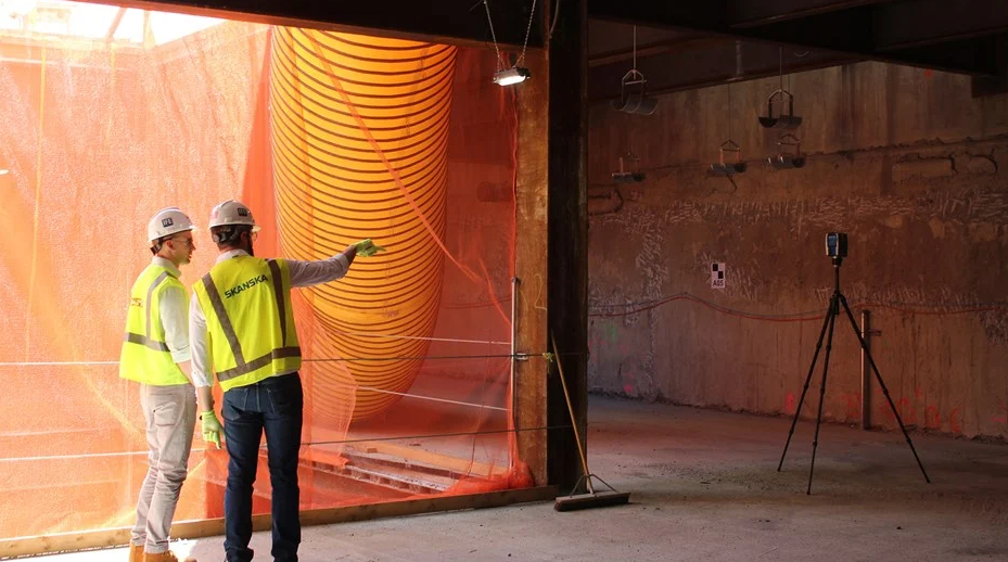
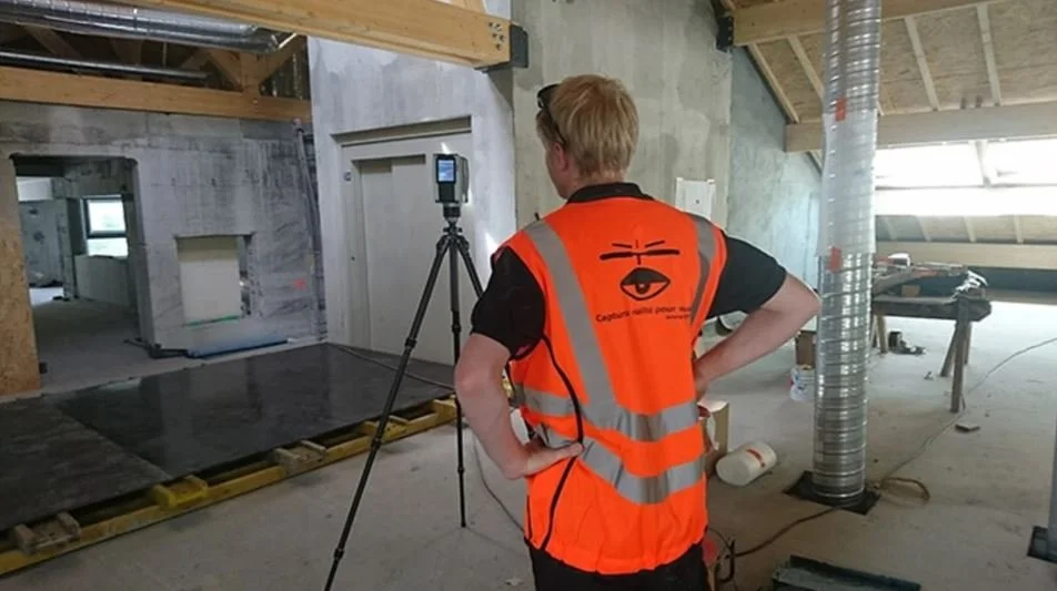
From Skanska
For construction and utility companies, one thing has become unavoidable in the last decade: the need for accurate, real-world data. Traditional blueprints and site walks are no longer enough to keep pace with the complexity of modern projects. Enter reality capture—a technology that’s reshaping the way the built environment is documented, understood, and managed.
Whether you’re undertaking a hospital renovation, building a new substation, or conducting safety audits at a power plant, reality capture offers a more precise, more efficient way to model the world. And when combined with Building Information Modeling (BIM), the result is a digital foundation that supports smarter decisions across the entire lifecycle of a project.
What Is Reality Capture—and Why Does It Matter?
From Engineers Ireland
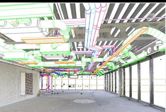
Reality capture uses technologies like LiDAR (Light Detection and Ranging), photogrammetry, and SLAM (Simultaneous Localization and Mapping) to create detailed, 3D point clouds of physical spaces. These scans form the basis of digital twins or BIM models, which, depending on the scanning technology used, can offer visual fidelity down to the millimeter.
This is more than just a 3D model. A scan-to-BIM process translates a point cloud into a structured digital asset—a model embedded with layers of metadata about structural elements, materials, and systems. These models become a single source of truth for engineers, contractors, owners, and facility managers.
In practical terms, it means faster project starts, fewer errors, better collaboration, and reduced on-site risk. In other words: real ROI.
How Utilities and Construction Firms Are Using Reality Capture
From initial planning to ongoing operations, reality capture is being applied throughout the asset lifecycle:
Design and Planning
Reality capture helps architects and designers in the early phases of a project by improving integration, identifying constraints, and streamlining project planning.
A McKinsey & Company blog pointed out the benefits: “In the design phase, a fully digital construction project can reduce drawing revisions, redundant conversations, and version errors while lowering project risk and facilitating clash detection.”
For example, ID Plans, a leading commercial real estate services provider, uses visual and spatial data to support sales, leasing, planning, and construction. By using Matterport’s detailed digital twins, ID Plans sped up design and construction planning, cut project costs, and kept projects on track, which led to up to 30% time savings.
With the right data, architects and engineers can spot issues before they become expensive change orders and increase project efficiency.
Construction
Frequent scans during construction allow teams to compare progress against the BIM model in real time. It’s easier to verify structural alignment, detect clashes, and keep timelines in check, which is especially valuable in prefabrication or modular construction workflows. By catching potential discrepancies early, these scans help avoid costly project delays and budget overruns.
Operations and Maintenance
Once a project is built, the data gathered throughout construction keeps paying dividends. Digital twins can be created by integrating BIM data with real-time data from sensors and other Internet of Things (IoT) devices.
Whether the project is a residential building, hospital, oil refinery, or something else, the digital twin can provide a real-time representation of the building and its systems. This data can be used for predictive maintenance, energy management, safety planning, and more.
Use Case: Reality Capture in High-Risk Environments
From Autodesk
An eye-opening example of the power of reality capture comes from ATFF, a French firm that specializes in scanning some of the world’s most dangerous and difficult-to-access environments. Their work has included nuclear facilities, high-voltage electrical substations, and mountaintop hospitals—all locations where traditional surveying would be time-consuming, risky, or outright impossible.
In one case, ATFF was called in to scan a nuclear plant. With safety protocols limiting how long technicians could remain on-site due to radiation exposure, speed was everything. Using laser scanners and pre-mapped workflows, the team captured millions of data points in minutes—turning a potentially hazardous process into a streamlined operation.
In another scenario, ATFF scanned a French electricity transformer site that powers nearly 90,000 homes. Due to airspace restrictions, aerial drones weren’t permitted. Being on site where deadly voltage was humming through transmission lines, the team had to work within strict zones while wearing protective gear. The scans were converted into point clouds and 3D models using Autodesk tools, and then were fed into BIM platforms. This output allowed remote engineers to plan upgrades in detail, all without exposing additional personnel to risk.
These technologies are bringing together more data than ever before. “When a surveyor went into the site, he just collected the data he needed,” ATFF Cofounder Florian Fauconnet said. “Reality capture is the inverse: We collect all the data. And after, we filter what you need.”
These are extreme examples, but the principle holds true for more routine applications. Whether mapping a congested mechanical room, assessing a heritage building for renovation, or maintaining underground utility infrastructure, reality capture reduces time on-site and increases the quality of information at your fingertips.
Why Now?
The combination of accessible scanning hardware and increasingly powerful cloud-based modeling tools means that reality capture is no longer reserved for mega-projects or high-end architecture firms. Solutions like Matterport and Autodesk streamline the process of converting scans into useful models, and the outputs integrate seamlessly with tools like Revit, BIM 360, and AutoCAD.
On top of that, advances in AI and automation are accelerating how quickly and accurately point cloud data can be turned into actionable models. We’re moving toward a future where every building, asset, and infrastructure network can have a living digital twin—updated in real-time, accessible from anywhere.
Final Thoughts
Reality capture is changing the game for the utility and construction industries. It offers unmatched accuracy, enhances safety, and supports a more collaborative and efficient approach to building and asset management.
With real-world success stories—like ATFF’s work in hazardous zones and ID Plan’s integrated approach—proving what’s possible, it’s clear this isn’t just a trend. It’s the new foundation for smarter infrastructure.
Playbook for Putting Reality Capture Into Action
Ready to bring the benefits of reality capture into your next construction or utility project? Here’s a practical playbook to help you move from interest to implementation:
1. Identify High-Impact Use Cases
Start by looking for areas where traditional surveying or documentation is slowing things down, introducing risk, or creating uncertainty. Common examples include:
Renovation of older assets with limited or outdated plans
Remote or hazardous sites where on-site time should be minimized
Projects with multiple subcontractors or stakeholders who need a shared model
2. Choose the Right Capture Method
Different environments call for different tools:
Drones are great for large exteriors and rooflines
Handheld or mobile mapping units work well indoors or for quick walkthroughs
LiDAR scanners provide high-resolution detail
Partner with a service provider that understands how to mix and match scanning hardware (and their data outputs) for the best results.
3. Select a BIM Workflow
Determine how you’ll convert your scans into usable BIM data. A few questions to ask:
What software will your team use to process point clouds (e.g., Autodesk ReCap)?
What BIM platform will house the final model (e.g., Revit, Archicad)?
Who is responsible for which roles in model creation and maintenance?
Clarify responsibilities early to avoid delays or mismatched expectations.
4. Establish a Collaboration Hub
Use platforms that support centralized model sharing, version control, and annotations. This ensures that all stakeholders—designers, contractors, engineers, and maintenance planners—are working from the same data at all times.
5. Pilot and Evaluate
Start small. Select one project, one site, or one facility to pilot reality capture. Measure success using metrics like:
Time saved on documentation or site visits
Accuracy of the resulting BIM model
Feedback from project teams on usability
Use lessons from the pilot to scale up intelligently.
6. Maintain and Expand
Once you’ve created a reality capture-enabled workflow:
Set up a schedule for re-scans to keep the model current
Incorporate the model into operations, maintenance, and planning
Use it for safety training, asset tracking, and space planning
Your digital twin doesn’t just support a project—it becomes a long-term asset.